Petrie: Then and Now

Main entry into North Pine (Petrie) via River Street, 1896Old Dayboro Road, Petrie, Qld

Sweeney Reserve is a beautiful park in Petrie where we’ve often gone to have a BBQ or picnic, or just to laze around and relax. It’s full of large trees, swings and plenty of space. I often ride through there on my bike most mornings.

I was amazed when I found this old photo from 1896 at the State Library of Queensland web site.  It was contributed to the State Library by Leith Barter on behalf of the Moreton Bay Regional Council along with about 150 other historical images.

In the centre of the old photo, you can see the North Pine Hotel, sitting on ground that is now part of the carpark at Woolworths Petrie. To the left and behind the hotel is the building which originally housed Tom Petrie’s hostelry and accommodation house. You can read more about the old photo here.

Today, the business centre of Petrie is close to the roundabout at the intersection of Anzac Avenue and Dayboro Road. But in the 1890’s the town centre was further south, approximately where the Woolworths carpark is now. In the early days, the main road north from Brisbane came through what is now Sweeney Reserve and up what is now Old Dayboro Road.

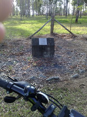
Out of curiosity, I had a quick look around the vacant lot near the Woolies carpark where the Hotel would have stood. There’s nothing there today. No marker, no ruins. Nothing. The pub was actually moved North East to where the current Petrie pub is today. But after that it was completely lost in a fire. There’s a replica of it today at “Old Petrie Town” on Dayboro Road.

Old Dayboro Road, Petrie, QldOld Dayboro Road, Petrie, QldOld Dayboro Road, Petrie, QldOld Dayboro Road, Petrie, Qld

Short Cut to School

The Short CutThe Short CutThe Short Cut

Towards the end of the nineteenth century, hundreds of small "Provisional Schools" sprung up around Queensland.

Kids needed to be educated, and schools needed to be within walking distance.

The deal was that if a community could guarantee at least 12 children, and a suitable building, the government would supply books, and a salary for a teacher.

One of these schools, set up in 1894 was the "Short Cut Provisional School" built at what is now Joyner near the present site of the North Pine Dam.

The school was used until 1915.

Many of these schools were rationalized in the early twentieth century as transport became more reliable and children were able to get to larger schools in the area.

Crossing the South Pine River

South Pine River Crossing


I discovered this pedestrian crossing of the South Pine River with Harrison last week end.

It’s at the southern end of Leitches Road, Brendale, and lets you cross the South Pine River by foot (or cycle) into Albany Creek.

I had no one to share it with this morning except for a few horses and a couple of skittish cows.

Absolutely beautiful, and a pleasant contrast from the horrible traffic on South Pine Road.

“Strathpine South A3 Field” at Brendale

A3 AirfieldA3 Airfield

In previous posts I told you about the A1 Airfield at Lawnton and the A2 (Spitfire Avenue) Airfield at Strathpine.

Today we visited the last of these three airfields – the Strathpine South A3 Field.

It’s in Brendale near the corner of South Pine Road and Linkfield Street.

An industrial estate mostly occupied by warehouses, the council has set aside one corner of the former airfield as a croquet field.

The airstrip was mostly used for emergency landings when the main A2 strip was unavailable due to wind direction.

Echoes in the Vineyard

Ebert VineyardEbert VineyardEbert VineyardEbert Vineyard

Just north of Lawnton Station, in a quiet back street, you’ll find an old grape vine growing on a chainwire fence next to the railway line.

It’s all that remains of a vineyard that Nikolaus and Christina Ebert planted on this spot in the 1860’s

His house was about 100 metres north of these vines, on what is now Ebert Parade.

Nikolaus, Christina and other members of the family are buried just up the road in Lawnton Cemetery alongside some of the other pioneers of the area.

The vineyards were ripped up before the railway line to Petrie and Gympie was laid. This vine re-grew and is a beautiful example of how the echoes from a bygone era may still be heard today.

Spitfires over Lawnton

A1 Airstrip - LawntonA1 Airstrip - LawntonA1 Airstrip - LawntonA1 Airstrip - Lawnton

There were three airfields in the Pine Rivers area during World War 2.

Most people are aware of the “Spitfire Avenue” Airstrip, also known as the A2 Strip in Strathpine. It was paved, and used heavily.

But not many people are aware of the A1 grass Strip which was built in the vicinity of Lawnton Pocket and Bells Pocket Roads.

It wasn’t paved, and was built as an emergency strip at an angle of about 60 degrees to the A2 strip. When planes were unable to land on the A2 strip due to wind, they could use the A1 strip.

Nothing much of it remains today. You can’t see any sign of it, except for the memorial erected by the council in 1995.

But the land is pretty flat!

There’s also a third strip south of here in Brendale. The A3 strip. One of these days I’ll ride down there and photograph it too!

In the meantime, I won’t have to try too hard to imagine the drone of Spitfires flying over my house.

UPDATE: I’ve just discovered Peter Dunn’s excellent Australia @ War site. He records that in 1942 2nd Lieutenant Maxwell J Jones (0429769) was tragically killed when his P-400 aicraft struck a tree while landing at the A1 airfield. Peter writes that the airfield was dangerous due to the fact that it was surrounded by large trees, and pilots often had to fly in an “S” shaped path on approach to the airfield in order to keep it in view – something that was very dangerous at low speed and low altitude.

Nuts about History

Historical NutsHistorical NutsHistorical Nuts

After a tip-off from our local historian, Leith Barter, I found these Pecan Nut trees growiung in Stephen Lawn park, Lawnton.

They were part of a grove planted by “The Acclimatisation Society” in the 1930’s – an organisation created to investigate how best to use the land in this area.

They’re almost 80 years old, and I was curious about them because we live not far from here, on land that was also part of the Acclimatisation Society, and we have a Pecan Nut tree too. But ours is nowhere near as well grown as these majestic specimens.

So the best that I can hope for is that our Pecan is the “son” of a historical nut tree!

Who knows? Maybe it sprouted from a nut dropped by one of the originals.

Thanks, Leith, for patiently answering so many of my questions about our local history!