


Simon and I caught the train up to Caboolture today and cycled back via Wamuran and Dayboro.
The aim was to explore an old historical road in our area and have fun while we were doing it.
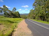
“The Old North Road” is a historic road which was established in 1843 by The Archer brothers (David, Thomas and John) and Evan Mackenzie as a quicker way to travel from Brisbane to Durundur Station and Kilcoy.
Parts of it remain to the North West of Brisbane (where it’s known as “Old Northern Road”, and up near Wamuran on the D’Aguilar Highway where it’s still known as “Old North Road”.
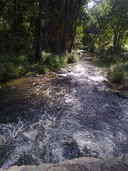
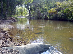
One of the pleasant surprises we found along the way was Zillman’s Crossing. It’s a causeway where The Old North Road crosses the Caboolture River in Rocksberg. This delightfully picturesque spot belies its history where horses, carts, and later cars would have a terrible time getting over the crossing.
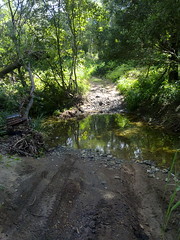
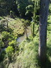
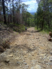
We also crossed Gregors Creek, an old dirt track at the southern end of F.Lindsay Road. This was originally part of the Old North Road, but became disused over the years. Click on the video for a superb demonstration of prowess as Simon shows how to cross a creek on a bike.

As this newspaper article from the Moreton Bay Courier (October 24 1846) reports, Gregors Creek was site of a gruesome murder.
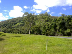
A little further south, and The Old North Road passed below Franz Mountain in Moorina. It overlooks a secluded valley which follows the banks of Burpengary Creek. Today the road is called “Franz Road” and passes south-east through some private property towards Narangba.
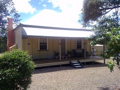
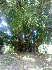
One of the beautiful old properties close to Franz Mountain is “Mary Ann’s Cottage“. This delightful cottage was built around 1880 by the son of one of the Moravian Missionaries, Maurice Schnieder and his wife Mary Ann. An outstanding native fig tree (Ficus Virens) stands proudly on the property, and is believed to be over 500 years old.
Meg Thomas, owner of Mary Ann’s Cottage has a fascinating collection of documents detailing the history of the property:


We’ll try to complete the northern section of The Old North Road next week, from Moorina to Whiteside.
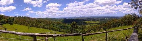
But to cap this leg of the journey off, we decided to follow an old dirt “short cut” up the side of Mt Mee. Exceeding a grade of 25% over a couple of kilometres, this has to be the steepest road I’ve ever tried cycling up. But the views were spectacular, and the exhilarating journey down the mountain after the summit made it a worthwhile climb.


Hi,
I read your article with great interest and especially noted the photograph of Gregors Creek and footage. I am trying to finish a book about Brisbane and the outskirts in the 1840s and 1850s and one segment concerns the deaths of Andrew Gregor and his servant Mary Shannon on 20 October 1846 in the vicinity of Gregor’s Creek which presumably runs off the North Pine River. I would be grateful if I could publish your photo of the creek. You may be aware that on 22 January 1848 Gregor’s brother, Reverend Gregor,drowned at a waterhole at Nundah (German Station) – some believed it was suicide. My Great Great grandfather (Johannes Gotfried Wagner) was one of the handful of German Missionaries who established German Station (Zion’s Hill) in 1838. He and others trekked out via the Pine River to the Bunya Mountains in 1842. They were told of the conflicts between aborigines and whites – undoubtedly catalysed by the so-called Kilcoy Massacre of aborigines. By all means contact me via julian_wagner [at] hotmail (dot) com or at work (07) 3229 2355. Best regards,Julian Wagner 13 December 2010.
G’day Julian
Please feel free to use any photos you need. And please let us know when your book is published, I’d love to buy a copy.
Regards
Neil
Hi,
I read with interest your musingsalong the North Road. My mother is Vera Franz and she grew up at the Franz farm at Moorina. I remeber holidays there. I was particularly interested to see the photo of Mary Ann’e cottage. Maurice Schneider was the son of My great great grandmother. She was pregnant with him on the voage to Australia. Her husband Moritz Schneider died from typhus contracted on the journey and she later married my great great grandfather Friedrich Leopold Franz. He was one of the first free settlers at the German station in Nundah and his son later moved to the Caboolture area. I am working on the family tree and notice that you have some other photos related to the cottage. I was wondering if you had any information about who the people were and whether I could get a copy, if they are related
Regards
Yvonne
G’day Yvonne
Thanks so much for your comments.
Mary Anne’s Cottage is now a lovely Bed & Breakfast operated by Meg Thomas. She has collected an impressive array of memorabilia about the cottage and its inhabitants over the last 170 years. I’m sure she will have a lot of the information you’re after. You can get her phone number from her web page at http://maryannscottage.com.au.
The Bauer family now lives at the old Franz farm on Franz Road. They’re in the white pages – the only “Franz” in Franz Road Moorina.
You’ve got some illustrious ancestors! Julian, who left a comment on this post earlier is a descendant of Johannes Wagner – one of the other German missionaries at Zion Hill / Nundah. Would you mind if I pass your information on to him?
Best wishes
Neil
another great article, i was always under the impression that the old road was one of the pathways that led from Brisbane up north eventually leading to the Blackall ranges used by the local first Australians and it was this track that Petrie and turbull people used to get to the Bonyi feast..:) here is some more info to understand why and how the murders took place, from what i have read they were revenge attacks from a massacre of Aboriginal people from the Kilcoy region, which in tribal lore was the way, two people were executed most notably ‘Dundali’ who was a tribal ‘turrwan'(great man) he was hung in post office square, and their is a street named after him in Chermside and Tom Petrie’s daughter named a former home after him..read on http://eprints.usq.edu.au/670/2/Connors_ANZLHE_2005_PV.pdf
http://eprints.usq.edu.au/7067/2/Connors_QHJ_v20N3_PV.pdf
Jason
Thanks for the info about Dundalli. I’ve read Dr Connor’s excellent article about the trial.
Did you read this article about Dundalli and the execution site?
http://blog.neilennis.com/index.php/dundalli/
Neil
I live in Frank Lindsay Rd near the “Old dirt crossing over Gregors Ck”.
There is two Gregors Creeks. The one mentioned by Neill Ennis has its source at Ocean View which is a little south of Mt Mee and flows into the Caboolture River a little downstream of Zillmans Crossing. There is another Gregors Creek south of Dayboro some where which would head towards the Pine River.
I have a book of Queensland Roads dated 1913, something similar to the old RACQ maps. The road system was vastly different to what you may expect then. The old highway went through Petrie, Caboolture and Landsborough.
In our area Caboolture River Road and Moorina Rd did not exist. Old North Rd although it is not named as such started at Petrie and,or,Samford and went north to Terrors Ck which I think is now Dayboro. It then followed the present Mt Mee Road up the range to Ocean View and then down a very steep hill now called Mountain View Rd to Moorina Rd. Along Moorina Rd for about a half mile and across to Frank Lindsay Rd upon which Neill rode his bike over Gregors Ck. Up Frank Lindsay Rd to Old North Rd across the Caboolture River at Zillmans Crossing and up to Wamuran. The Caboolture – Wamuran – Woodford road was a main road then. As far as I can tell the Old North Road near Aspley is a different Road to the Old North Rd near Wamuran and also different to the Old North Rd near Glasshouse as of 1913. A elderly local told me that the stage coaches of Cobb and Co used to use our Old North Rd coming from Dayboro to Wamuran. They would want to have good brakes coming down Mountain View Rd from Ocean View as the steepness would test most 4wd brakes as they would have to be in low gear also.Stage coaches did not have gear boxes.
Hope that helps or confuses the issue.
G’day Lance
Thanks for the info.
I’ve cycled up Mountain View Road to Ocean View – never down it. That would have been terrifying in a horse drawn coach!
Neil
I’m trying to trace some history from Kelvin Grove via Enoggera following what used to be The Road to Durandur and the Old North Road. I’m as far as Enoggera mentioning the Road to Durandur on a map but would like to following the route further to Kilcoy in the 1800’S If there is a book published I would be interested to purchase. I really enjoyed following the bike tour and photos. Many thanks for the information printed. Yours in history, Merle
G’day Merle
Thanks for your comments.
It’s a bit difficult to know where the Old North Road went exactly but there are clues.
Many local libraries plus the Dept. of Environment and Resource Management have a series of cadastral maps from the late 19th century showing old property boundaries and old roads. A useful series is the AG2 Moreton 40 Chain Map series and the 20 chain maps. If you know where to look it’s possible to see the road reserve related to the Old North Road on these maps. Bear in mind that the Old North Road was in disuse by about 1860, and these cadastral maps were created 30 to 40 years after that.
A second clue is the creek crossings. The Old North Road had several important crossings whose locations we can guess to within one or two hundred metres:
1. South Pine River / Cashs Crossing – near the current bridge on South Pine Road Albany Creek, probably 100m to the east.
2. Four Mile Creek, near Acland Drive Warner, south west of Bray Park High. It’s named “Four Mile Creek” because it was four miles south of where the Old North Road crossed the North Pine River.
3. One Mile Creek, at the foot bridge between Gordons Crossing Road East and Gordons Crossing Road West, Warner. It’s named “One Mile Creek” because it was one mile south of where the Old North Road crossed the North Pine River.
4. Gordons Crossing. Where the Old North Road crossed the North Pine River. Unfortunately this crossing is now under Lake Samsonvale / North Pine Dam.
5. Mosquito Creek. On Smiths Road South (A dirt track), south of Eric McSweeney Court, Kurwongbah.
6. Burpengary Creek. On Franz Road near the corner of Haywood Road, Moorina.
7. Browns Creek, south-west of the end of F.Lindsay Road, Rocksberg.
8. Caboolture River, Zilman’s Crossing, Rocksberg.
As far as I know there are no books on the subject, but you might like to check out the “Museum of Lands, Mapping and Surveying” at Wooloongabba. They have lots of old survey plans and maps. The curator of the museum may be able to help: https://www.dnrm.qld.gov.au/mapping-data/maps/research-history/museum
Hope this helps.
Neil
Hi, Mary Shannon was my Great Great Great Grandmother.
I am fascinated to see the area. But more than anything, I would like to find where she and her baby are buried, and have her taken from that awful place and interred properly and with dignity. All she has now is a plaque in Caboolture cemetery, for which we are grateful.
Who is going to help me find her? I am permanently bed bound with spinal cord injuries.